
Four Arches Over the Dee: Pont Fawr, Llandderfel
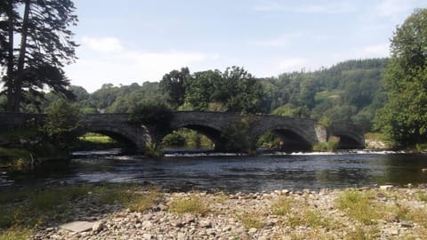
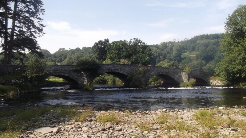
On a still morning the River Dee slides beneath Pont Fawr with barely a sound, passing through four broad arches of rough grey stone. Half a kilometre south of Llandderfel, the bridge has carried travellers between Bala and Corwen for the better part of three centuries. Beyond its parapets the valley opens out into pasture, and the church tower rises above the trees on the far side.
Come with us to this quiet corner of Gwynedd, where a sturdy bridge, a Celtic saint and a vanished railway line tell the story of a village shaped by a river.
A Village Named for a Warrior Saint
Llandderfel takes its name from the church of St Derfel, known as Derfel Gadarn, or Derfel the Mighty. Tradition places him in the early 6th century and describes a soldier who turned to the religious life and founded a church beside the Dee. The church is first recorded in the Taxatio of 1291, and the Welsh heritage record notes an earlier mention in 1254.
In the Middle Ages the church became a major place of pilgrimage. Visitors came to pray before a large wooden image of the saint, and Derfel was honoured as a protector of livestock, so offerings were made for the welfare of animals. His feast day, 5 April, drew crowds, and the village grew around the shrine. Roads that led pilgrims here gave the river crossing its importance.
Two Bridges Built as One
Pont Fawr, meaning simply the Great Bridge, is older than it first looks and more complicated. Cadw, the Welsh historic environment service, describes it as a bridge of two periods. The downstream half probably dates from the second half of the 17th century. In the middle or third quarter of the 18th century the whole structure was doubled in width on its upstream side, creating the broad crossing seen today.
The bridge is built of local rubble stone and has four segmental arches. The two central arches are taller and wider than those on either side, to let the Dee pass in times of spate. Triangular cutwaters break the force of the current, and the parapets are capped with slate slabs. At the southern end the road curves gently east between retaining parapets. Cadw lists the bridge at Grade II*, and it is also a scheduled monument, protected for what it can still reveal about post-medieval building and transport.
Keeping the Road Above the Floods
The Dee does not stay politely between its banks, and the builders of Pont Fawr knew it. Immediately west of the main bridge, Pont-y-Bryn carries the road across the floodplain on five small arches, set within a raised, parapeted causeway. It probably dates from the 17th or 18th century and was linked to its larger neighbour in the early 19th century. Beside it, a group of low flood arches with flat slate lintels lets high water drain away rather than pile up against the embankment.
The causeway has been repaired over the years, and one section of parapet was rebuilt in 1983 and 1984. Together the two bridges form a single, carefully engineered crossing, and visitors who walk it today follow the same line travellers have used for centuries.
Reformation, Chapels and a Railway
The pilgrimage did not survive the Reformation. In 1538 the great wooden figure of Derfel was taken to London and burned in the same fire that killed the Franciscan friar John Forest at Smithfield. Local memory kept hold of the saint all the same. A carved wooden figure known as Ceffyl Derfel, Derfel's Horse, survives in the church porch, and some accounts describe it as a stag.
The church itself is an early Tudor rebuilding, probably from the early 16th century, and keeps an oak rood screen thought to date from around 1500. It was restored in 1870 by S Pountney Smith of Shrewsbury at a cost of £1,200. By then Nonconformity was strong in the district, and the 1887 Ordnance Survey map shows a settlement that had spread to either side of the church, with a school, a sawmill and two chapels, one Independent and one Calvinistic Methodist.
The Great Western Railway added a station at Llandderfel on 1 April 1868, on the line between Ruabon and Barmouth. It closed in the winter of 1964, when floodwater from the Dee breached the track nearby and the damaged section never reopened. The river that Pont Fawr was built to cross had, in the end, outlasted the railway.
Visiting Llandderfel Today
Llandderfel is a small, sparsely populated community about 5 kilometres north-east of Bala. The parish church and the Methodist chapel remain open as places of worship. The old Independent chapel and the sawmill have closed, and the station site is now disused, though an arch of the railway bridge can still be reached beneath the road.
Pont Fawr is best seen on foot. Walk to the parapet, look upstream and downstream to see the two phases of building, and then follow the causeway across to Pont-y-Bryn. The road is a working one, so take care with traffic, and allow time to visit the church, where the carved horse waits in the porch.
A Crossing That Endured
Few structures show so plainly how a place grows around a river crossing. Pont Fawr was built to serve a pilgrim village and later widened for heavier traffic, and it stood firm while a railway came and went. Its four arches still carry the road over the Dee, linking the village to the wider valley as they have for generations.